

Review Article
Open Access
Suez Canal: The Modern Maritime Wonder
Khandakar Akhter Hossain*
Department of Naval Architecture and Marine Engineering, Bangladesh University of Engineering & Technology, Bangladesh
*Corresponding author: Khandakar Akhter Hossain; Department of Naval Architecture and Marine Engineering, Bangladesh University of Engineering
& Technology, Bangladesh, Tel: +880 312501207; E-mail:
@
Received: July 20, 2018; Accepted: August 20, 2018; Published: August 23, 2018
Citation: Akhter Hossain K (2018) Suez Canal: The Modern Maritime Wonder. Int J Sci Res Environ Sci Toxicol 3(3):1-10. DOI: 10.15226/2572-3162/3/3/00123
Abstract Top
Canal Suez is one of the supreme engineering wonder of the
world. The canal is owned and maintained by the Suez Canal Authority
(SCA) of Egypt. Suez Canal is connecting Mediterranean and Red Seas
and was officially opened on Nov 17, 1869. This maritime wonder
took more than 15 years to plan and build. The Canal construction
was repeatedly hundred by political disputes, labor shortages and
even a deadly cholera outbreak. When finally completed, the 101 NM
long waterways permanently transformed international shipping
by allowing vessel to skip the long and deceitful transit around the
southern tip of Africa. The Suez Canal has enjoyed increased traffic
in recent years, with roughly 50 ships passing through its waters
every day. However, the canal is still hampered by its narrow width
and shallow depth, which are insufficient to accommodate two
way traffic from modern tanker ships. In 2014, Egypt’s Suez Canal
Authority announced an ambitious plan to deepen the canal and
create a new 22-mile lane branching off the main channel. Preliminary
work has already begun which Egyptian authorities claim could more
than double the canal’s annual revenue by 2023. It is an interesting
reviewed paper based both on primary and on secondary information
and some critical analysis. Paper describes history, engineering
wonders, interesting fact and figure of Suez Canal and excellent
ambition of human and present status of one of the maritime success
of shipping trade that improving the international maritime business
and transportation.
Keywords: Canal; Suezmax; Traffic;
Keywords: Canal; Suezmax; Traffic;
Introduction
The Suez Canal (in Arabic Qanat al-Suwais) is an artificial
sea-level waterway in Egypt, connecting the Mediterranean
Sea and the Red Sea. Canal has opened in November 17, 1869
after 10 years of construction by a French private company. Its
construction has repeatedly hindered by political disputes, labor
shortages and even a deadly cholera outbreak. It allows ships to
travel between Europe and South Asia without navigating around
Africa, thereby reducing the sea voyage distance between Europe
and India by about 8,200 kilometers (5,100 nm) [1]. The northern
terminus is Port Said; the southern terminus is Port Tewfik at the
city of Suez. Ismailia is on its west bank, 3 km (1.9 nm) from the
half-way point. In 2012, 17225 vessels traversed the canal (47
vessels per day). When built, the canal was 164 km (102 nm)
long and 8 m (26 ft) deep [2]. After several enlargements, it is
193.30 km (120.11 nm) long, 24 m (79 ft) deep and 205 meters
(673 ft) wide. It consists of the northern access channel of 22 km,
the canal itself of 162.25 km and the southern access channel
of 9 km. The Canal is really not wide enough to allow two way
passages of ships, but there are several passing bays and areas
where ships may pass each other in the Bitter Lakes and between
Qantarah and Ismailia. The Suez Canal has no locks, because the
Mediterranean Sea and the Gulf of Suez have roughly the same
water level. In general, the canal north of the Bitter Lakes flows
north in winter and south in summer. Three convoys transit the
canal on a typical day, two southbound and one northbound [3].
The canal handle averages about 8% of the world shipping traffic.
The passage of ship takes between 11 and 16 hours at a speed
of around 8 knots. Canal Suez is one of the greatest engineering
feats of modern record. The canal is owned and maintained by
the Suez Canal Authority (SCA) of Egypt. Under the Convention of
Constantinople, it may be used “in time of war as in time of peace,
by every vessel of commerce or of war, without distinction of flag
[4].” In August 2014, construction was launched to construct a
second canal, the New Suez Canal, for half of the route of the canal,
costing US$ 8.4 billion, to increase the canal’s capacity. Funding
was arranged by issuing interest-bearing investment certificates
exclusively to Egyptian entities and individuals and the target
amount was collected over only six working days. The expansion
is expected to double the capacity of the Suez Canal from 49 to 97
vessels a day. President Abdel Fattah al-Sisi of Egypt has invested
in an expansion of the Suez Canal which began in 2014. The Suez
Canal authority said in a statement that, Egypt’s revenue from the
Suez Canal for the 2017-2018 financial year rose 11.5 percent to a
record high $5.585 billion, (by CAIRO Reuter) [27]. [Figures 1& 2].

Figure 1: Importance and geographical location of Suez Canal shown in maps [31].

Figure 2: Northern outlet and Southern terminus respectively of the Suez Canal
Historical Chronology of Suez Canal
Suez Canal is connecting Mediterranean and Red Seas and
was officially opened in a great ceremony at Egypt’s, Port Said
on Nov 17, 1869 [5].The canal took more than 15 years to plan
and build. Its construction was repeatedly hundred by political
disputes, labor shortages and even a deadly cholera outbreak.
When finally completed, the 101 NM long waterways permanently
transformed international shipping by allowing vessel to skip the
long and treacherous transit around the southern tip of Africa [6].
There is exciting, surprising and eventful history about the canal
that links the Eastern and Western worlds.
Canal Origins Date back to Ancient Egypt
The modern Suez Canal is only the most recent of several
manmade waterways that once snaked their way across Egypt.
The Egyptian Pharaoh Senusret III may have built an early canal
connecting the Red Sea and the Nile River around 1850 B.C.,
and according to ancient sources, the Pharaoh Necho II and the
Persian conqueror Darius both began and then abandoned work
on a similar project [30]. The canal was supposedly finished in
the 3rd century B.C. during the Ptolemaic Dynasty. There are
many historical figures including Cleopatra may have traveled on
it. Rather than the direct link offered by the modern Suez Canal,
this ancient “Canal of the Pharaohs” would have wound its way
the through the desert to the Nile River, which was then used to
access the Mediterranean [7].
Roman and Muslim Understand the Strategic Importance
of Canal
This canal is said to have been extended to the Red Sea by
Ptolemy II Philadelphus (285-246 BC), abandoned during the
early Roman rule, but rebuilt again by Trajan (98-117 AD) Over
the next several centuries, it once again was abandoned and
sometimes dredged by various rulers for various but limited
purposes. Amr Ibn el-As rebuilt the canal after the Islamic
takeover of Egypt creating a new supply line from Cairo, but in
767 AD, the Abbasid caliph El-Mansur closed the canal a final
time to cut off supplies to insurgents located in the Delta [7]. Of
course, over time, ships grew in size and so the ancient attempts
to connect the two seas would not have worked anyway today.
Napoleon Bonaparte Building Plan
After conquering Egypt in 1798, the French military
commander Napoleon Bonaparte sent a team of surveyors to
investigate the feasibility of cutting the Isthmus of Suez and
building a canal from the Red Sea to the Mediterranean. But
following four separate excursions to the region, his scouts
incorrectly concluded that the Red Sea was at least 30 feet
higher than the Mediterranean. Any attempt to create a canal,
they warned, could result in catastrophic flooding across the
Nile Delta [7]. The surveyors’ faulty calculations were enough
to scare Napoleon away from the project, and plans for a canal
stalled until 1847, when a team of researchers and engineers
finally confirmed that there was no serious difference in altitude
between the Mediterranean and Red Seas [29].
British Government Opposed Construction
Planning for the Suez Canal officially began in 1854, when a
French former diplomat named Ferdinand de Lesseps negotiated
an agreement with the Egyptian viceroy to form the Suez Canal
Company. Since Lesseps’ proposed canal had the support of the
French Emperor Napoleon III, many British statesmen considered
its construction a political scheme designed to undermine their
dominance of global shipping [8]. The British ambassador to
France argued that supporting the canal would be a “suicidal
act,” and when Lesseps tried to sell shares in the canal company,
British papers labeled the project “a flagrant robbery gotten up to
despoil the simple people.” Lesseps went on to engage in a public
war of words with British Prime Minister Lord Palmerston, and
even challenged railway engineer Robert Stephenson to a duel
after he condemned the project in Parliament. The British Empire
continued to criticize the canal during its construction, but it
later bought a 44 percent stake in the waterway after the cashstrapped
Egyptian government auctioned off its shares in 1875.
Canal Built by both Forced Peasant Labor and State-ofthe-
Art Machinery
Building the Suez Canal required massive manpower, and
the Egyptian government initially supplied most of the labor by
forcing the poor to work for nominal pay and under threat of
violence. Beginning in late-1861, tens of thousands of peasants
used picks and shovels to dig the early portions of the canal by
hand. Progress was painfully slow, and the project hit a snag after
Egyptian ruler Ismail Pasha abruptly banned the use of forced
labor in 1863. Faced with a critical shortage of workers, Lesseps
and the Suez Canal Company changed their strategy and began
using several hundred custom-made steam- and coal-powered
shovels and dredgers to dig the canal [9]. The new technology
gave the project the boost it needed, and the company went on
to make rapid progress during the last two years of construction.
Of the 75 million cubic meters of sand eventually moved during
the construction of the main canal, some three-fourths of it was
handled by heavy machinery.
The Statue of Liberty Originally Intended for the Canal
As the Suez Canal neared completion in 1869, French sculptor
Frédéric-Auguste Bartholdi tried to convince Ferdinand de
Lesseps and the Egyptian government to let him build a sculpture
called “Egypt Bringing Light to Asia” at its Mediterranean
entrance. Inspired by the ancient Colossus of Rhodes, Bartholdi
envisioned a 90-foot-tall statue of a woman clothed in Egyptian
peasant robes and holding a massive torch, which would also
serve as a lighthouse to guide ships into the canal [32]. The project
never materialized, but Bartholdi continued shopping the idea for
his statue, and in 1886 he finally unveiled a completed version
in New York Harbor. Officially called “Liberty Enlightening the
World,” the monument has since become better known as the
Statue of Liberty. Having silenced his critics by completing the
Suez Canal, Ferdinand de Lesseps later turned his attention
toward cutting a canal across the Isthmus of Panama in Central
America. Work began in 1881, but despite Lesseps’ prediction
that the new canal would be “easier to make, easier to complete,
and easier to keep up” than the Suez, the project eventually
descended into chaos. Thousands died during construction in the
sweltering, disease-ridden jungle, and the team burned through
nearly US$ 260 million without ever completing the project.
The company finally went belly up in 1889, triggering a massive
scandal that saw Lesseps and several others-including Eiffel
Tower designer Gustave Eiffel, who had been hired to design
canal locks-convicted of fraud and conspiracy [11]. It would take
another 25 years before the Panama Canal was finally completed
in a decade-long, American-led construction project.
Opening the Canal by French
The canal opened under French control on 17 November
1869. Although numerous technical, political, and financial
problems had been overcome, the final cost was more than
double the original estimate. The canal had an immediate and
dramatic effect on world trade. Combined with the American
transcontinental railroad completed six months earlier, it allowed
the world to be circled in record time. It played an important role
in increasing European colonization of Africa. The construction
of the canal was one of the reasons for the Panic of 1873, because
goods from the Far East were carried in sailing vessels around
the Cape of Good Hope and were stored in British warehouses.
As sailing vessels were not adaptable for use through the canal,
because the prevailing winds of the Mediterranean blow from
west to east, British entrepôt trade suffered. External debts
forced Said Pasha’s successor, Isma’il Pasha, to sell his country’s
share in the canal for £4,000,000 (about £85.9 million in 2014) to
the United Kingdom in 1875, but French shareholders still held
the majority. Prime Minister Benjamin Disraeli was accused by
William Ewart Gladstone of undermining Britain’s constitutional
system, because he had not referred to, or obtained consent from
Parliament when purchasing the shares with funding from the
Rothschilds. When it opened, the Suez Canal was only 25 feet
deep, 72 feet wide at the bottom, and 200 to 300 feet wide at the
surface. Consequently, fewer than 500 ships navigated it in its
first full year of operation. Major improvements began in 1876,
however, and the canal soon grew into the one of the world’s
most heavily traveled shipping lanes [12]. In 1875, Great Britain
became the largest shareholder in the Suez Canal Company when
it bought up the stock of the new Ottoman governor of Egypt.
Seven years later, in 1882, Britain invaded Egypt, beginning a
long occupation of the country. The Anglo-Egyptian treaty of
1936 made Egypt virtually independent, but Britain reserved
rights for the protection of the canal. 8. Britain Gain Control in
1882. The Convention of Constantinople in 1888 declared the
canal a neutral zone under the protection of the British, who had
occupied Egypt and Sudan at the request of Khedive Tewfiq to
suppress the Urabi Revolt against his rule. The revolt went on
from 1879 to 1882. As a result of British involvement on the side
of Khedive Tewfiq, Britain gained control of the canal in 1882.
The British defended the strategically important passage against
a major Ottoman attack in 1915, during the First World War [12].
Under the Anglo-Egyptian Treaty of 1936, the British retained
control over the canal. In 1951 Egypt repudiated the treaty, and in
October 1954 the British agreed to remove its troops. Withdrawal
was completed on 18 July 1956. [Figure 3]

Figure 3: The opening of the Suez Canal on November 17, 1869 (The
Print Collector/Getty Images)
Cold War-Era Crisis
In 1956, the Suez Canal was at the center of a brief war
between Egypt and the combined forces of Britain, France and
Israel. The conflict had its origins in Britain’s military occupation
of the Canal Zone, which had continued even after Egypt gained
independence in 1922. Many Egyptians resented the lingering
colonial influence, and tensions finally boiled over in 1956.
Egypt pressed for evacuation of British troops from the Suez
Canal Zone, and in July 1956 Egyptian President Gamal Abdel
Nasser nationalized the canal, hoping to charge tolls that would
pay for construction of a massive dam on the Nile River [29]. In
response, Israel invaded in late October, and British and French
troops landed in early November, occupying the Canal Zone [14].
Under pressure from the United Nations, Britain and France
withdrew in December, and Israeli forces departed in March
1957. That month, Egypt took control of the canal and reopened
it to commercial shipping. [Figure 4]
Arab-Israel Crisis and Yellow Fleet
During June 1967’s Six Day War between Egypt and Israel,
the Suez Canal was shut down by the Egyptian government and
blocked on either side by mines and scuttled ships. At the time
of the closure, 15 international shipping vessels were moored at
the canal’s midpoint at the Great Bitter Lake. They would remain
stranded in the waterway for eight years, eventually earning the
nickname the “Yellow Fleet” for the desert sands that caked their
decks. Most of the crewmembers were rotated on and off the
stranded vessels on 3-month assignments, but the rest passed
the time by forming their own floating community and hosting
sporting and social events [15]. As the years passed, the fleet even
developed its own stamps and internal system of trade. The 15
marooned ships were finally allowed to leave the canal in 1975.
By then, only two of the vessels were still seaworthy enough to
make the voyage under their own power.[Figure 5]

Figure 4: Sunken ships during the 1956 Suez Canal Crisis (Fox Photos/
Getty Images)

Figure 5: Ferdinand Marie de Lesseps, Master Planner and panoramic view of today’s Suez City.
Geology
The Isthmus of Suez, the sole land bridge between the
continents of Africa and Asia, is of relatively recent geologic
origin. Both continents once formed a single large continental
mass, but during the Paleogene and Neogene periods (about 66
to 2.6 million years ago) the great fault structures of the Red Sea
and Gulf of Aqaba developed, with the opening and subsequent
drowning of the Red Sea trough as far as the Gulf of Suez and
the Gulf of Aqaba. In the succeeding Quaternary Period (about
the past 2.6 million years), there was considerable oscillation of
sea level, leading finally to the emergence of a low-lying isthmus
that broadened northward to a low-lying open coastal plain
[31]. There the Nile delta once extended farther east-as a result
of periods of abundant rainfall coincident with the Pleistocene
Epoch (2,588,000 to 11,700 years ago)-and two river arms,
or distributaries, formerly crossed the northern isthmus, one
branch reaching the Mediterranean Sea at the narrowest point
of the isthmus and the other entering the sea some 9 miles (14.5
km) east of present Port Said [16].
Physiography
Topographically, the Isthmus of Suez is not uniform. There
are three shallow water-filled depressions: Lake Manzala, Lake
Timsah, and the Bitter Lakes; though distinguished as Great and
Little, the Bitter Lakes form one continuous sheet of water. A
number of more-resistant bands of limestone and gypsum obtrude
in the south of the isthmus, and another significant feature is a
narrow valley leading from Lake Timsah southwestward toward
the middle Nile delta and Cairo. The isthmus is composed of
marine sediments, coarser sands, and gravels deposited in the
early periods of abundant rainfall, Nile alluvium (especially to the
north), and windblown sands.
Canal Construction
When first opened in 1869, the canal consisted of a channel
barely 8 meters deep, 22 meters wide at the bottom, and 61 to
91 meters wide at the surface. To allow ships to pass each other,
passing bays were built every 8 to 10 km. Construction involved
the excavation and dredging of 74 million cubic meters of
sediments. Between 1870 and 1884 some 3,000 groundings of
ships occurred because of the narrowness and tortuousness of
the channel [17]. Major improvements began in 1876 and, after
successive widening and deepening, the canal by the 1960s had
a minimum width of 55 meters at a depth of 10 meters along
its banks and a channel depth of 12 meters at low tide. Also in
that period, passing bays were greatly enlarged and new bays
constructed, bypasses were made in the Bitter Lakes and at
Al-Ballāḥ, stone or cement cladding and steel piling for bank
protection were almost entirely completed in areas particularly
liable to erosion, tanker anchorages were deepened in Lake
Timsah, and new berths were dug at Port Said to facilitate the
grouping of ships in convoy. Plans that had been made in 1964
for further enlargement were overtaken by the Arab-Israeli war
of June 1967, during which the canal was blocked. The canal
remained inoperative until June 1975, when it was reopened
and improvements were recommenced. In 2014 the Egyptian
government announced plans for a nearly US$ 8.5 billion project
to upgrade the canal and significantly increase its capacity [18].
Included in the project is a second lane to allow ships to pass
north and south concurrently, expected to be completed at end
of 2015.
Economy
In 1870, the canal’s first full year of operation, there were 486
transits, or fewer than 2 per day. In 1966 there were 21,250, an
average of 58 per day, with net tonnage increasing from some
444,000 metric tons in 1870 to about 278,400,000 metric tons.
By the mid-1980s the number of daily transits had fallen to an
average of 50, but net annual tonnage was about 355,600,000
metric tons [20]. In 2014 there were 17,148 transits with a net
annual tonnage of about 963,000,000 metric tons.[Figure 6]

Figure 6: Width and Cross-sectional area of Suez Canal expanded with time.
Convoy Sailing
Since the canal does not cater for unregulated two-way
traffic, all ships transit in convoys on regular times, scheduled
on a 24-hour basis. Each day a single northbound convoy starts
at 06.00 from Suez, getting an unhindered passage. At by-passes,
the convoy uses the eastern route. Interwoven in this convoy’s
passage are two southbound convoys. The first starts at 0.00
from Port Said, and anchors in the Great Bitter Lake to let the
northbound pass; the second starts at 07.00 and anchors in the
western Ballah by-pass to let the northbound convoy pass. Due to
the Ballah canal dimensions; this convoy is restricted to smaller
and often unloaded ships.
Operation
The canal does not permit two-way traffic. Originally, ships
would stop in a passing bay to allow the passage of ships in
the other direction. Transit time then averaged 40 hours, but
by 1939 it had been reduced to 13 hours. A system of convoys
was adopted in 1947, consisting of one northbound and two
southbound per day [29]. Transit time went up to 15 hours in
1967 despite convoying, reflecting the great growth in tanker
traffic at that time [19]. With some enlargement of the canal,
transit time since 1975 has ranged from 11 to 16 hours. Upon
entering the canal at Port Said or Suez, ships are assessed for
tonnage and cargo (passengers have ridden without charge
since 1950) and are handled by one or two pilots for actual canal
transit, which is increasingly controlled by radar. Southbound
convoys moor at Port Said, Al-Ballāḥ, Lake Timsah, and Al-
Kabrīt, where there are bypasses that allow northbound convoys
to proceed without stopping. The nature of traffic has greatly
altered, especially because of the enormous growth in shipments
of crude oil and petroleum products from the Persian Gulf since
1950. In 1913 the oil in northbound traffic amounted to 291,000
long tons (295,700 metric tons), whereas in 1966 it amounted
to 166,000,000 long tons (168,700,000 metric tons). The closure
of the canal from 1967 to 1975 led to the use of large oil tankers
on the route around the Cape of Good Hope and prompted the
development of the Sumed pipeline from Suez to Alexandria,
which opened in 1977. Since 1975 the increased size of tankersthe
largest of which cannot use the canal—and the development
of sources of crude oil in areas outside of the canal route (e.g.,
Algeria, Libya, Nigeria, the North Sea, and Mexico) have reduced
the canal’s importance in the international oil trade [21]. From an
all-time peak of 984,000 in 1945, passenger traffic has declined
to negligible numbers because of the competition from aircraft.
Further decline in canal traffic resulted from a shift of Australasian
trade from Europe to Japan and East Asia. Some movement of oil,
however, from refineries in Russia, southern Europe, and Algeria
has continued, chiefly to India, and the shipment of dry cargoes,
including grain, ores, and metals, has increased. A more recent
feature has been the growth of container and roll-on/roll-off
(ro-ro) traffic through the canal, chiefly destined for the highly
congested ports of the Red Sea and Persian Gulf [22]. The major
northbound cargoes consist of crude petroleum and petroleum
products, coal, ores and metals, and fabricated metals, as well as
wood, oilseeds and oilseed cake, and cereals. Southbound traffic
consists of cement, fertilizers, fabricated metals, cereals, and
empty oil tankers.
Navigation
The canal has no locks because of the flat terrain, and the
minor sea level difference between each end is inconsequential
for shipping. As the canal has no sea surge gates, the ports at
the ends would be subject to the sudden impact of tsunamis
from the Mediterranean Sea and Red Sea, according to a 2012
article in the Journal of Coastal Research. There is one shipping
lane with passing areas in Ballah-Bypass near El Qantara and
in the Great Bitter Lake. On a typical day, three convoys transit
the canal, two southbound and one northbound. The passage
takes between 11 and 16 hours at a speed of around 8 knots
(15 km/h; 9 mph). The low speed helps prevent erosion of the
banks by ships’ wakes. New Rules of Navigation came into force
on 1 January 2008, passed by the board of directors of the Suez
Canal Authority (SCA) to organize vessels’ transit. The most
important amendments include allowing vessels with 62-foot
(19 m) draught to pass, increasing the allowed breadth from 32
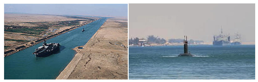
Figure 7: American aircraft carrier and an Egyptian Submarine in the Suez Canal.
meters (105 ft) to 40 meters (130 ft) (following improvement
operations), and imposing a fine on vessels using divers from
outside the SCA inside the canal boundaries without permission
[23]. The amendments allow vessels loaded with dangerous
cargo (such as radioactive or flammable materials) to pass if they
conform to the latest amendments provided by international
conventions. The SCA has the right to determine the number of
tugs required to assist warships traversing the canal, to achieve
the highest degree of safety during transit.[Figure 7].
Interesting Fact and Features
• Canal Length: 120.11 miles or 193.30 km (originally 102 nm
or 164 km)
• Maximum boat beam: 77.5 m (254 ft 3 in)
• Locks: None
• Original Owner: Suez Canal Company (Compagnie Universelle du Canal Maritime de Suez, French)
• Construction began: April 1859, 25
• Date completed: November 17, 1869
• Start point: Port Said
• End point: Port Tewfik, Suez
• Branch(es): The New Suez Canal.
Digging Sand Remove
Of the 75 million cubic meters of sand eventually moved
during the construction of the main canal, some three-fourths of
it was handled by heavy machinery.
Suezmax
The canal allows passage of ships up to 20 m (66 ft)draft
or 240,000 deadweight tons and up to a height of 68 m (223 ft)
above water level and a maximum beam of 77.5 m (254 ft) under
certain conditions.
Traffic
The canal can handle more traffic and larger ships than the
Panama Canal. Some supertankers are too large to traverse the
canal. Others can offload part of their cargo onto a canal-owned
boat to reduce their draft, transit, and reload at the other end of
the canal.
Alternative Sea Route
The main alternative sea route rather than Suez Canal
is around Cape Agulhas, the southernmost point of Africa,
commonly referred as the Cape of Good Hope route. This was the
only sea route before the canal was constructed, and when the
canal was closed [24]. It is still the only route for ships that are
too large for the canal.
Piracy Problem
In the early 21st century the long route has enjoyed increased
popularity because of increasing piracy in Somalia. Between 2008
and 2010, it is estimated that the canal lost 10% of traffic due to
the threat of piracy, and another 10% due to the financial crisis.
Reduce Distance
An oil tanker going from Saudi Arabia to the United States has
2,700 nm (4,345 km) longer to go when taking the route south of
Africa rather than the canal.
Before Canal
Before the canal’s opening in 1869, goods were sometimes
offloaded from ships and carried overland between the
Mediterranean and the Red Sea.
The Suez Canal Bridge
Also called the Egyptian-Japanese Friendship Bridge, a highlevel
road bridge at El Qantara. In Arabic, al qantara means “arch”.
It has a 70-metre (230 ft) clearance over the canal and was built
with assistance from the Japanese government and by Kajima.
El Ferdan Railway Bridge
20 km (12 mi) north of Ismailia was completed in 2001 and is
the longest swing span bridge in the world, with a span of 340 m
(1100 ft) [29]. The previous bridge was destroyed in 1967 during
the Arab-Israeli conflict.
Fresh Water Supply
Pipelines taking fresh water under the canal to Sinai, about
57 km (35 mi) north of Suez.
Ahmed Hamdi Tunnel
South of the Great Bitter Lake was built in 1983. Because of
leakage problems, a new water-tight tunnel was built inside the
old one from 1992 to 1995.
Overhead Power Line
The Suez Canal overhead power-line crossing was built in
1999.
Railway
A railway on the west bank runs parallel to the canal for its
entire length.
Sea Route
A graphical comparison between the Northern Sea Route
(blue) and an alternative route through Suez Canal (red).
First Open Operation
When it opened, the Suez Canal was only 25 feet deep, 72
feet wide at the bottom, and 200 to 300 feet wide at the surface.
Consequently, fewer than 500 ships navigated it in its first full
year of operation [25].
World Sea Trade
By 1955 about two-thirds of Europe’s oil passed through the
canal. Around 8% of world sea trade is carried via the canal.
Vessel Crossing Annually
In 2008, 21415 vessels passed through the canal.
Average Cost Per Ship
The average cost per ship is US $ 251,000. In 2008, the
receipts totaled US $ 5.381 billion.
Transit Time
Typically it takes a ship 12 to 16 hours to transit the canal.
Daily Capacity
The canal’s 24-hour capacity is about 76 standard ships.
First President of the Suez Canal Company
Ferdinand de Lesseps (15 December 1858 - 7 December
1894).
Present Chairmen of the Suez Canal Authority
Admiral Mohab Mamish (2012 -present).[Figure 8].

Figure 8: A high-level road bridge on Suez Canal and a Container-ship crossing the Suez Canal.
Important Timelines
• 25 April 1859- Construction officially starts by French Private
Company (Owner name was Ferdinand Marie de Lesseps).
• 17 November 1869- The canal is opened, owned and operated by Suez Canal Company.
• 18 December 1873- The International Commission of Constantinople establishes the Suez Canal Net Ton and the Suez Canal Special Tonnage Certificate (as known today)
• 25 November 1875- Britain becomes a minority share holder in the company, acquiring 44%, with the remainder being controlled by French business syndicates.
• 20 May 1882- Britain invades Egypt, with French assistance, and begins its occupation of Egypt [26].
• 25 August 1882- Britain takes control of the canal.
• 2 March 1888- The Convention of Constantinople renews the guaranteed rite of passage of all ships through the canal during war and peace; these rights were already part of the licenses awarded to de Lesseps, but are recognised as international law.
• 14 November 1936- Following a new treaty, Britain theoretically pulls out of Egypt, but establishes the ‘Suez Canal Zone’ under its control [29].
• 13 June 1956- Suez Canal Zone is restored to Egyptian sovereignty, following British withdrawal and years of negotiations.
• 26 July 1956- Egypt nationalizes the company; its Egyptian assets, rights and obligations are transferred to the Suez Canal Authority, which compensates the previous owners at the established pre-nationalization price. Egypt closes the canal to Israeli shipping as part of a broader blockade involving the Straits of Tiran and the Gulf of Aqaba.
• 31 October 1956 to 24 April 1957- the canal is blocked to shipping following the Suez Crisis, a conflict that leads to Israeli, and later French and British, occupation of the Canal Zone [26].
• 22 December 1956 – The Canal Zone is restored to Egyptian control, following French and British withdrawal, and the landing of UNEF troops.
• 5 June 1967 to 10 June 1975- the canal is blocked by Egypt, following the war with Israel; it becomes the front line during the ensuing War of Attrition and the 1973 war, remaining closed to international shipping, until general agreement was near.
• 1 January 2008- New rules of navigation passed by the Suez Canal Authority come into force.
Ecological Balance of Two Seas
The opening of the canal created the first salt-water passage
between the Mediterranean and the Red Sea. Although the Red
Sea is about 1.2 m (4 ft) higher than the eastern Mediterranean,
the current between the Mediterranean and the middle of the
canal at the Bitter Lakes flows north in winter and south in
summer. The current south of the Bitter Lakes is tidal, varying
with the tide at Suez [23]. The Bitter Lakes, which were hyper
saline natural lakes, blocked the migration of Red Sea species into
the Mediterranean for many decades, but as the salinity of the
lakes gradually equalized with that of the Red Sea the barrier to
migration was removed, and plants and animals from the Red Sea
have begun to colonies the eastern Mediterranean.
Future Expansion of Canal
The Suez Canal has enjoyed increased traffic in recent years,
with roughly 50 ships passing through its waters every day.
Shipping tolls allow Egypt to rake in around $ 5 billion annually,
but the canal is still hampered by its narrow width and shallow
depth, which are insufficient to accommodate two-way traffic
from modern tanker ships. In August 2014, Egypt’s Suez Canal
Authority announced an ambitious plan to deepen the canal
and create a new 22-mile lane branching off the main channel.
Preliminary work has already begun on the US $ 8.5 billion
project, which Egyptian authorities claim could more than double
the canal’s annual revenue by 2023 [28].[Figure 9]

Figure 9: Expansion of Canal is in Progress.
Northern Sea Route as New Advanture
In recent years, the shrinking Arctic sea ice has made the
Northern Sea Route feasible for commercial cargo ships between
Europe and East Asia during a six-to-eight-week window in the
summer months, shortening the voyage by thousands of miles
compared to that through the Suez Canal. According to polar
climate researchers, as the extent of the Arctic summer ice pack
recedes the route will become passable without the help of
icebreakers for a greater period each summer. The Bremen-based
Beluga Group claimed in 2009 to be the first Western company to
attempt using the Northern Sea Route without assistance from
icebreakers, cutting 4000 nautical miles off the journey between
Ulsan, Korea and Rotterdam, the Netherlands [30].
Conclusion
Suez Canal is a sea-level waterway running north-south
across the Isthmus of Suez in Egypt to connect the Mediterranean
and the Red seas. The canal separates the African continent from
Asia, and it provides the shortest maritime route between Europe
and the lands lying around the Indian and western Pacific oceans.
It is one of the world’s most heavily used shipping lanes (handle
more than 8% of world shipping traffic). The canal extends 101
nm (163 km) between Port Said in the north and Suez in the
south, with dredged approach channels north of Port Said, into
the Mediterranean, and south of Suez. The canal does not take
the shortest route across the isthmus, which is only 75 nm (121
km). Instead, it utilizes several lakes: from north to south, Lake
Manzala, Lake Timsah, the Great Bitter Lake and Little Bitter
Lake. The Suez Canal is an open cut, without locks, and, though
extensive straight lengths occur; there are eight major bends. To
the west of the canal is the low-lying delta of the Nile River, and
to the east is the higher, rugged, and arid Sinai Peninsula. Today,
more than 50 ships navigate the canal daily, carrying more than
900 million tons of goods a year and collect more than US $ 5
billion annually [26]. Prior to construction of the canal (completed
in 1869), the only important settlement was Suez, which in 1859
had 3,000 to 4,000 inhabitants. The rest of the towns along its
banks have grown up since, that time. In August 2014, Egypt’s
Suez Canal Authority announced an ambitious plan to deepen
the canal and create a new 22-mile lane branching off the main
channel and which could allow second lane to ships convoy to
pass north and south concurrently and more than double the
canal’s annual revenue by 2023. However, Suez Canal is one the
greatest modern maritime wonder of the world
ReferencesTop
- Suez Canal guide. Marine Services Co. 2010;
- Official Web Site of the Suez Canal Authority.
- New Suez Canal project proposed by Egypt to boost trade. Cairo News Net. 2014;
- Encyclopedia Britannica, 11th edition, s.v. "Suez Canal". 2008;
- Hassan FA and Tassie GJ. Site location and history. Kafr Hassan Dawood On-Line, Egyptian Cultural Heritage Organization. 2003;
- J H Breasted. Attributes the ancient canal's early construction to Senusret III, up through the first cataract.
- J H Breasted. Ancient Records of Egypt, Part One. Chicago. 1906: 642-648.
- The Columbia Encyclopedia, Sixth Edition, sv. Suez Canal. 2008;
- The Elder Pliny and John Healey. Natural History (6.33.165) Penguin Classics. 2004;
- Shea William H. A Date for the Recently Discovered Eastern Canal of Egypt. In Bulletin of the American Schools of Oriental Research. 1977;226:31-38.
- Hess Richard S. Israel in Egypt: The Evidence for the Authenticity of the Exodus Tradition, by James K. Hoffmeier. The Denver Journal. 2008;
- Montet Pierre. Everyday Life in the Days of Ramesses the Great. Philadelphia: University of Pennsylvania Press. 1981:184.
- Silver Morris. Ancient Economies II, "5c. Evidence for Earlier Canals." ANCIENT ECONOMIES II. Economics Department, City College of New York. 2008;
- Cambyses II (king of Persia) - Encyclopedia Britannica.
- Tuchman and Barbara. Bible and Sword: How the British came to Palestine. MacMillan London. 1987;
- Linda Hall Library. Kansas City, Missouri. The Search for the Ancient Suez Canal, accessed. 2008;
- Derek Hopwood. Elie Podeh; Onn Winckler. Rethinking Nasserism: Revolution and Historical Memory in Modern Egypt. 2006;17(2): 221-223. Doi:10.1093/jis/etl017
- Canal Characteristics. Suez Canal Authority. 2010;
- Finkl Charles W, Pelinovsky Efim, Cathcart Richard B. A Review of Potential Tsunami Impacts to the Suez Canal. Journal of Coastal Research. 2012;28(4):745-759. Doi:10.2112/JCOASTRES-D-12A-00002.1
- Traffic system. Egyptian Maritime Data Bank (EMDB). 2013;
- Stephen Kalin and Yasmine Saleh. Egypt awards Suez hub project to consortium that includes army: sources. 2016;
- Egypt to build new Suez Canal. 2014;
- Navigation, Convoy System. Suez Canal Authority. 2013;
- Phenomenon of Lessepsian Migration, Colloquial Meeting of Marine Biology I, Salzburg. 2001;
- Tour Egypt. 2017;
- Egypt State Information Service (Cairo). 2015;
- Egypt's Suez Canal reports record high $5.585 billion annual revenue. 2018;
- Suez Canal II: The sequel that impresses no one. 2018;
- Suez Canal revenues reach $3 billion since start of 2016.
- Suez Canal History. 2017;
- Suez Canal. 2018;
- Mohit. The Suez Canal: A Man-Made Marvel Connecting the Mediterranean and Red Sea. 2018;

